Youngstown 2010 Plan
Chapter 7: Planning Districts
North Side Planning District
The North Side Planning District consists of three neighborhoods and part of an industrial district. Brier Hill, North Heights, Wick Park and the northern section of the Riverbend Industrial Park are contained in this cluster. Traces of Youngstown’s early settlement, economic, industrial and cultural history are scattered throughout these neighborhoods.
Location
The North Side Planning District is bounded by the Mahoning River on the west, the City of Girard and Liberty Township on the North, Crab Creek on the east and the Madison Avenue Expressway on the south. The District occupies parts of both Mahoning and Trumbull Counties.
Neighborhoods
Brier Hill
The Brier Hill neighborhood grew on the homestead of early Youngstown industrialist and Ohio’s Civil War governor, David Tod. Tod’s mines provided coal for his mills and subdivision of his land provided housing for the miners and iron workers that provided muscle for such enterprises. Brier Hill grew as an unincorporated village inside Youngstown Township until it was absorbed by the City in stages between 1880 and 1900.
The rapid expansion of industry was a pull factor for the entire Mahoning Valley and Brier Hill served as an entry point for early immigrants, Welsh, Irish, Italian and African American as they, like the raw materials they processed, coalesced and became the strength of a rapidly growing industrial region. Th e coal mines that fueled the iron industry are
long gone and the old rooming houses are either razed or in various stages of disrepair.
Brier Hill has the last working vestige of Youngstown’s steelmaking past, V & M Star, a pipe producing mini-mill located in the buildings of the former Brier Hill Works of the Youngstown Sheet and Tube Company. Th e chaos that spawned Brier Hill is still evident in its current land use. Brier Hill contains a mixture of residual ethnic influences (churches and stores), industry, public housing and vast tracts of open land that were once residences. As the population of Youngstown moved up and out, much of Brier Hill was simply left behind.
Wick Park
What Brier Hill was to the working class, the Wick Park neighborhood was to the wealthier residents of Youngstown. During Youngstown’s preindustrial days, transportation was primarily on foot or horse drawn. Initial residential development was clustered in what would become the downtown. Wealth was irrelevant to residential location because the village had to be walkable. As transportation improved, the upper classes could afford, financially and timewise, to move away from the densely populated core. This movement, blocked by the steep ridge to the south, was towards the north away from the noise and grime of the mills and commerce. Migration originally proceeded up Wick Avenue to Madison and flowed towards the park and continued up Fifth Avenue.
Wick Park, a gift to the City from the family whose name it bears, was designed as an open space with horse trails. It straddled the City’s northern border in 1880 and by 1890 was entirely within the city limits. The area adjacent to the park and on Fifth Avenue north of the park was the domain of Youngstown’s rich and famous. Th e trappings of wealth faded with distance from Wick Park and Fifth Avenue. Working class apartments and houses fi lled in the residential land between Wick Avenue and Elm Street, and along the hillside above Andrews Avenue. Many residential structures still remain with uses ranging from funeral homes to group homes, while much of the northern extent of Fifth Avenue retains its status with an active upper end real estate market.
North Heights
The North Heights neighborhood grew as demand for housing for all classes expanded with Youngstown’s industrial base. The bulk of the neighborhood came into the City as part of the 1929 annexation with the rest of Youngstown Township. Wealthy residents took advantage of the prestige of Fifth Avenue and frontages along Crandall Park and the Henry Stambaugh Golf Course. The working class resided along the hillside that rose from the Crab Creek industrial district up to Ohio Avenue while middle class residents filled in between.
Conditions
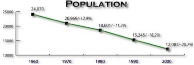
Population
The North Side, like the City has experienced an average of 16% population decline every ten years for the past 40 years and over half its total population. It is anticipated that this trend will slow and the population will stabilize.
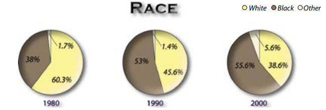
Race
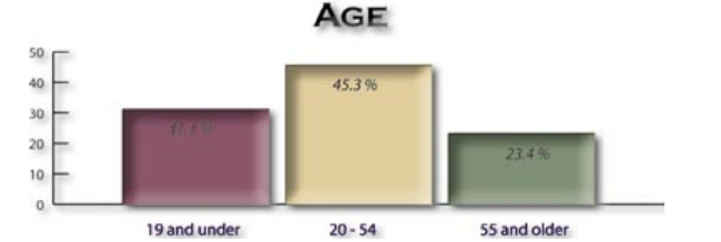
Age
Housing, Vacant and Abandoned Properties
Chapter 4 chronicles what has been left behind by suburban flight and deindustrialization. Housing has been particularly impacted, as housing stock that once held in excess of 170,000 people now contains only 82,000 (see section 4.4 Housing). Excess housing is both a liability to existing neighborhoods and an opportunity to fi nd alternative uses for surplus residential land.
Over time many units have been removed from the City’s housing stock, but removal has lagged behind the rate of disinvestment and abandonment. Youngstown has been left with nearly 3,500 housing units in excess of what the current population can support. Th is agglomeration of economically nonviable housing induces further blight and abandonment. Patterns of blight and disinvestment are not geographically uniform.
Neighborhoods have been impacted dramatically differently. Patterns of stable housing, blight, disinvestment and open space are all evident in the North Side district (see Map 26). All North Side neighborhoods show signs of blight, but there are heavy concentrations throughout Brier Hill, in the Wick Park and North Heights neighborhoods east of Elm Street.
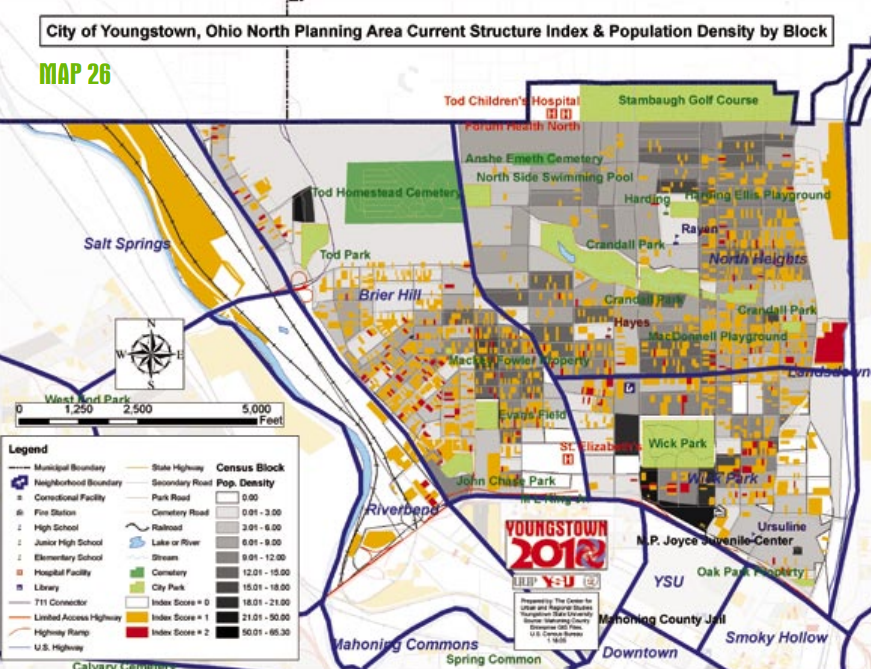
North Heights west of Elm Street is relatively stable. Population density ranges from relatively nonexistent in northern Brier Hill and along the Andrews Avenue corridor to relatively dense around YSU. Years of disinvestment have also left clusters of vacant land, both from removed structures and land never developed, throughout the North Side (see Map 27). Patterns of vacant land tend to match the patterns of blight, providing graphic evidence that excess housing and unchecked blight lead to eventual abandonment and removal. Northern Brier Hill demonstrates the ultimate result, nearly total disinvestment. Other sections of Brier Hill are following the same path. Sections of the North Side east of Elm Street show the same pattern. Between Belmont Avenue and Elm Street, the majority of land is in use. The patterns of bight and abandonment on the North Side show problems and opportunities.
This resource is an abridged version of the Youngstown 2010 plan. You can access the full version in pdf format below.