Youngstown 2010 Plan
Chapter 6: The Youngstown 2010 CityWide Plan
Plan Themes
The Youngstown 2010 planning process from the vision through the neighborhood cluster planning meetings produced four recurring themes. These themes are the guiding forces behind the future land use map.
1. Green Network
The desire for a cleaner and greener city was constant. A key to this ‘gray to green’ transformation is the creation of a green network. This involves linking the existing green spaces in the city via water courses and trails, expanding or protecting green space that should stay green and linking the City’s green network to the larger network of the region, state and nation.
2. Competitive Industrial Districts
Youngstown has become a leader in the creative reuse of old industrial brownfield sites. This has yielded state of the art industrial parks that fit comfortably in the new industrial green classification. Continued refinement of this ‘gray to green’ development process can keep Youngstown competitive within the new regional and global economies.
3. Viable Neighborhoods
Youngstown has viable neighborhoods on all sides of town. Celebrating their enduring vitality and stabilizing these neighborhoods gives the City a starting point from which to reclaim some of the adjacent neighborhoods that have not so successfully withstood the test of time.
4. Vibrant Core
Youngstown’s compact core, once the center of activity in the Mahoning Valley, is already recovering. The visioning process, every neighborhood meeting, every meeting with neighboring political units and the University’s Centennial Master Plan emphasized the importance of a vibrant downtown. Building off the recent Federal Street renovations, convocation center construction, federal and state courthouse construction, state office buildings and arts expansion, new restaurants, night clubs and housing projects, vibrancy is returning to the core.
The themes distilled from the Youngstown 2010 Vision and planning process led to the creation of a land use plan (see Map 18) that will be used as a roadmap for Youngstown’s future. This was constructed land use layer by land use layer. The step by step process follows.
Recreation and Open Space
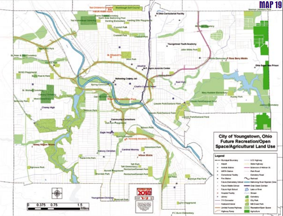
Recreation and open space deals with the greener aspects of land use, and is in itself not one, but many land uses. Youngstown has always had green space and recreation, but it has not been the focus of a comprehensive city plan, let alone examined from a regional perspective. The Youngstown 2010 Citywide Plan seeks to make these vital linkages (see Map 19).
The visioning process called for a greener Youngstown and being generous with our available urban land. Th e consensus at all the neighborhood meetings was to keep the existing green space green, create new recreational opportunities, and link to the regional recreational system.
The land use set aside for green space and recreation in the Youngstown 2010 Citywide Plan addresses these issues. Existing open space is protected in several ways. Two new land classifications (i.e. recreation/open space and agriculture) are identified. This plan also provides linkages between recreational opportunities in the City and region by establishing greenways along river and stream corridors so that hike and bike trails allow access to all facilities. Cleaning and gaining access to the Mahoning River is integral to establishing regional recreational linkages. Adequate recreational opportunities have become a major factor for business location, especially with high tech firms. Local and regional linkages will make Youngstown more attractive to such business.
Industrial
Youngstown, like the rest of America’s industrial belt, has learned that the future of industry is no longer limited to the fire-and smoke-belching factories of its past. While the transition through several new economies has not been easy, Youngstown is left with new possibilities for the watercourses that were the lifeblood of its heavily industrial past.
The Youngstown 2010 Citywide Plan creates a new industrial land use, industrial green, for a new reality. Global shifts in manufacturing have made it clear that the land currently zoned for heavy and light industry will never again be used to its full potential, and that these classifications are not only a liability to the City’s watercourses and air but to a sustainable
future. Uses currently permitted in heavy and light industrial are remnants of a past that has left not only Youngstown but America. The Vision that guided this planning process called for a cleaner and greener Youngstown and at every community meeting that sentiment was reiterated. Industry is still welcome in Youngstown, but as the Salt Springs, Performance Place and Ohio Works Industrial Parks have shown, new industry can be environmentally friendly. These remediated brownfield sites are examples of the new “industrial green” land use classification with their non-polluting activities, landscaped grounds and lack of outside storage.
The Youngstown 2010 Citywide Plan actually increases the amount of land intended for industrial use to 4,200 acres, while decreasing the set asides for heavy and light industry to 490 and 350 acres respectively. Heavy and light industrial uses are permitted in the Youngstown 2010 Citywide Plan, but are far less extensive (see Map 20).
This is mostly an acknowledgement to remnants of the old system that have survived deindustrialization. Heavy industry is confined to the northwest and southeast approaches to the City along the Mahoning River. V & M North Star Steel
occupies the former facilities of the Youngstown Sheet and Tube Brier Hill Works in the northwest section of the city. The site is isolated from residential areas by the 711 Connector and various reclaimed brownfield industrial sites.
The other section that remains heavily industrial is along the river on the southeast side where the Youngstown Sheet and Tube Campbell Works and the Republic Steel Youngstown Works formerly stood.
The Campbell Works is part of the Mahoning River Corridor of Opportunity district, and may eventually be the location of a planned district requiring overlay zoning. Part of the planned district will be heavy industrial; in lieu of overlay zoning the Campbell Works will retain its heavy industrial use.
Light industrial, a category that harbors uses somewhere between heavy and green, is only 15% of its former extent. Much of what was classified as light industrial meets the criteria for inclusion into the new green category. The remaining light industrial is composed of land with residual industry that was part of the former heavy industrial complex, or has other characteristics that exclude it from industrial green. Only three clusters remain.
The largest cluster stretches from the 711 Connector through the Riverbend Industrial Park between the Mahoning River and Martin Luther King Jr. Boulevard. This area contains, among others, relics of the Brier Hill Works, asphalt and cement plants, the City Street Department, an active foundry and other light manufacturing and distribution facilities. All these activities yield an area that is not heavy industry, but not green either.
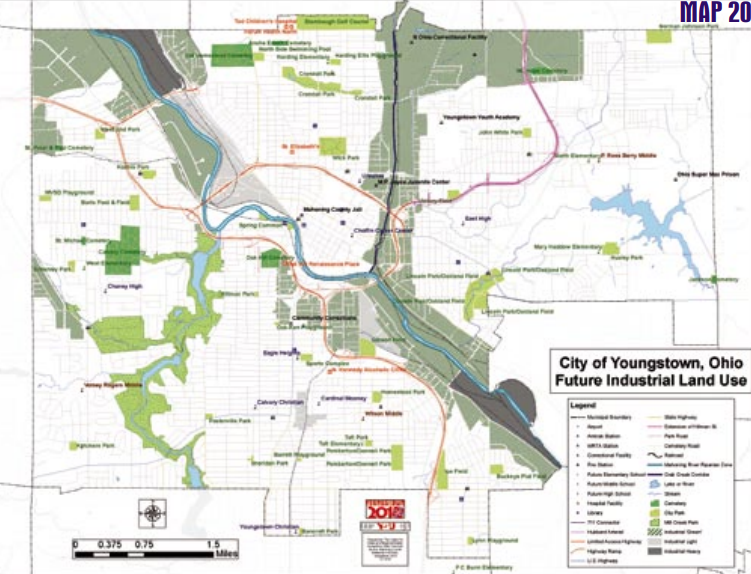
The other remaining light industrial areas also exhibit special circumstances. The largest cluster houses the City’s sewage treatment plant. Processing the sewage for the city and parts of adjacent suburbs is technically a ‘green’ activity; tertiary treatment of sewage before it is released into the river has greatly improved water quality. During this process, the plant produces odors and uses and stores on site hazardous chemicals that preclude it from industrial green classification.
The third island of light industrial is new to the category. Th is cluster straddles the South Side’s Erie and Cottage Grove Neighborhoods in the deeply incised Gibson Run Valley. The current zoning is commercial. The actual use is a mix of metal fabricators with outdoor cranes and pipe storage, building supply distributors and other small companies that congregated along what was the Youngstown and Southern Railroad. Some evidence of the areas coal mining past is still visible along the rail line. The overall character of this place is light industrial. One of the most exciting pieces of the Youngstown 2010 industrial land use section is the inclusion of industrial green as an official land use. The plan places approximately 3,300 acres of land from other uses into this new category. Most land is shifted from the other industrial categories, but some residential and commercial areas are also shifted. Industrial green differs from previous classifications in that it requires non-polluting environmentally friendly industries.
This classification also encourages preservation and rehabilitation of open space as part of the overall site design. Industrial green land use straddles the Mahoning River where commercial, heavy and light industrial uses are not now active. This category also occupies the entire Crab Creek basin, and stretches across the City’s northern border from Crab Creek to the western edge of the Sharon Line/McGuff ey Heights Neighborhood. Crab Creek is a major tributary to the Mahoning River, and as the Mahoning River, restoration project takes place, abandoned environmental hazards need to be remediated and current polluting activities need to be abated.
Benefits of cleaning the Mahoning River are diluted if contaminants still flow freely down the major tributaries. The existing industries along Crab Creek can take advantage of the green status to create workplace amenities such as hiking and biking along a restored Crab Creek. Greening the Crab Creek basin also creates linkage opportunities with the green network throughout the City and the region. Th ese types of green opportunities are attractors to business and industry in the new millennium.
The City’s brownfield reclamation industrial parks, Performance Place, Salt Springs and Ohio Works are examples of how the industrial green classification functions. They are occupied by environmentally friendly industries where green space is viewed as an asset. Instead of the mills and slag dumps that previously occupied these sites, there is an aesthetic mix of modern buildings and landscaped open space. In the case of the Ohio Works, it is anticipated that its connection to the Mahoning River will become enhanced green space. Much of the development along Industrial Road and the old Y & A rail line on the City’s West Side meets the criteria for industrial green and becomes part of this new classification.
Residential
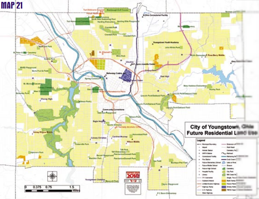
The future land use plan (see Map 21) calls for a thirty percent decrease in land intended for residential use. With the City’s historic population losses and the overabundance of residential land from the previous plans, this is a rather conservative reduction in residential land. Leaving excess land in residential use allows the City to retain the ability to absorb new residential development should the need arise. The requirement that all new residential development obtain approval from the planning commission and council helps to ensure that future residential development will not be scattered and haphazard.
Commercial
Time was not kind to the commercial land use plans of the City, and as population suburbanized, retail and other commercial activities were quick to follow. What was left was an overabundance of commercial land and abandoned commercial structures. Many of the neighborhoods abutting the commercial corridor have been abandoned and cleared. Th e corridors and their commercial buildings have become facades hiding empty neighborhood space.
The Youngstown 2010 Citywide Plan does eliminate some of the excess commercial space, but leaves the major corridors open for commercial use (see Map 22). Total acreage in commercial use drops to 965, sixteen percent less than the old plan. This was accomplished by converting the old ‘Wick Six’ auto dealership area, Industrial Road, and the commercial spaces along the northern stretches of South Avenue and Market Street to industrial green. The commercial space allocated to the Lincoln Knolls Plaza, Glenwood Avenue and the Uptown District was reduced. Other than a decrease in the amount of commercial land, major adjustments include separating the Central Business District from the rest of the commercial land use, and the establishment of commercial nodes (neighborhood business districts) along the corridors.
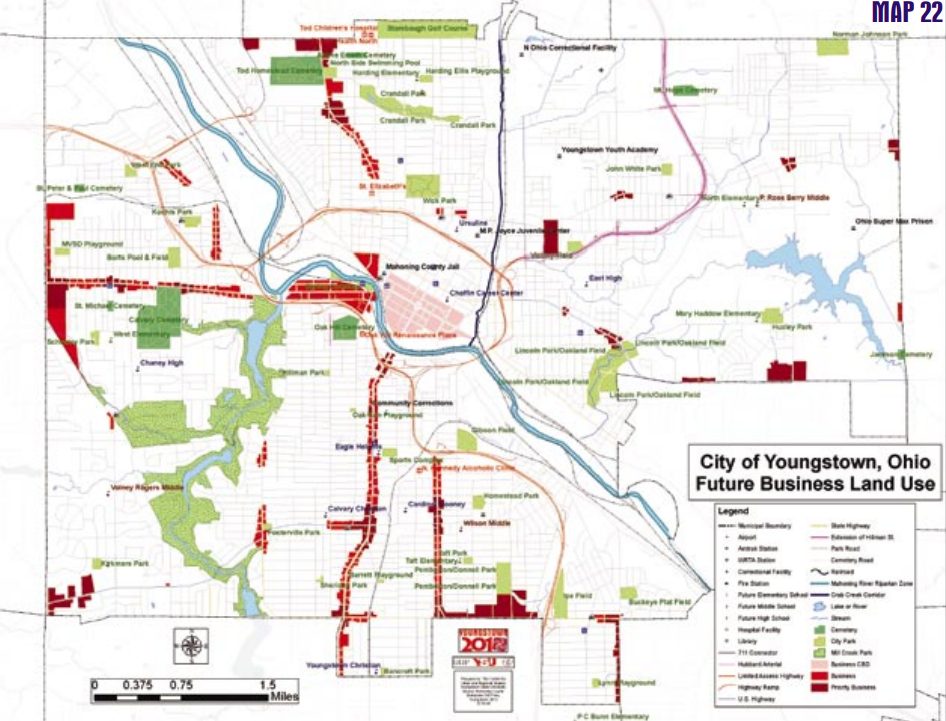
The Central Business District has always been given a separate zoning classification from other commercial designations because of the uniqueness and importance of the core. Making it distinct among commercial areas in the Youngstown 2010 Citywide Plan reinforces this significance.
It is essential with the opening of the convocation center, the rehabilitation of Federal Street and the increase in entertainment activity downtown that land use flexibility is maintained. New courthouses and University projects show the commitment of federal, state and county governments to the downtown area. Combine this with the perceived demand for housing in the upper floors of commercial buildings and the willingness of developers to risk their own money, and it becomes apparent that downtown is reclaiming some of the luster that had been tarnished during deindustrialization.
Downtown is predominant but it is not the only commercial space in the City. The commercial corridors along the City’s gateways are the first impression to visitors coming to Youngstown. The City cannot support the level of commercial activity that would allow full occupation of the remaining space in the commercial corridors.
To help focus commercial activity along the corridors in places where it will have the most impact, an overlay of priority business nodes where commercial activity should be focused was created.
These key intersections along the corridors generally already contain clusters of viable retail and commercial activity. They contain establishments that are frequented on a regular basis and generate not only automobile but pedestrian traffic. Commercial classification was left along the entire corridor so that any entity that wishes to establish commercial activity in these zones will be allowed to do so, but the goal of this plan is to focus revitalization efforts in these nodes first. These priority business clusters will serve as growth poles and as demand develops, growth will spread outward along the corridor.
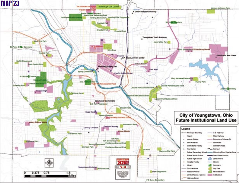
Institutional
This resource is an abridged version of the Youngstown 2010 plan. You can access the full version in pdf format below.